
Conference Finals live Chat room
-
I understood, and I was giving you the geography. Any other questions of the sort?
Nah, thanks. I told you that because Orion had already responded to my question. I know that USA has California, Texas, Florida, Washington, Ohio, Louisiana... And fortysome Dakotas.
Nah, thanks. I told you that because Orion had already responded to my question. I know that USA has California, Texas, Florida, Washington, Ohio, Louisiana... And fortysome Dakotas.
You of all people shouldn't forget Maine. Remember the Maine? We had to kick your asses in a war over the Maine.


-
Here is some geographical data: States who had teams win the most Championships (NFL, AFL, AAFC)
Ohio: 13 (4 or 5 franchises: Pro/Rams/Browns/Bulldogs)
Wisconsin: 13.....all Packers
New York: 11....Jets/Giants/Bills (note...count Jets/Giants as NY even though they play in New Jersey)
California: 11... Chargers/Rams/49ers/Raiders
Pennsylvania: 11.....Yellow Jackets/Eagles/Steelers
Illinois: 10 Bears/Cardinals
Texas: 8 .....Cowboys/Dall. Texans/Oilers
Massachussets: 5 Patriots
Maryland: 5: Colts/Ravens
Washington DC: 5 Redskins (count as DC even though they play in Maryland)
Michigan: 4......Lions
Colorado: 3.....Broncos
Florida: 3.....Dolphins, Bucs
Missouri: 3.....Chiefs/Rams
Indiana: 1....Colts
Louisiana: 1....Saints
Washington State: 1 Seahawks
Rhode Island: 1 Steam Roller
(states that currently have teams, but have never won a title: Arizona, Minnesota, Tennessee, North Carolina, Georgia
(states that currently have teams, but have never won a title: Arizona, Minnesota, Tennessee, North Carolina
Georgia?
You of all people shouldn't forget Maine. Remember the Maine? We had to kick your asses in a war over the Maine.
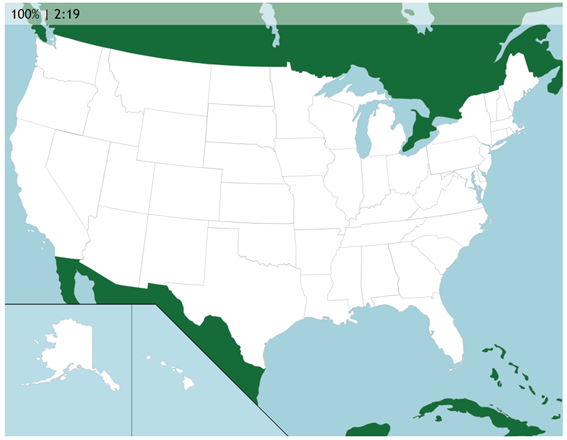
Lol. Damn you... I remember Maine, I was just setting up the joke. In fact, it's 7pm and I'm still studying so I decided to rehearse my knowledge of the states at https://online.seterra.com/en/vgp/3003... Here are the results:
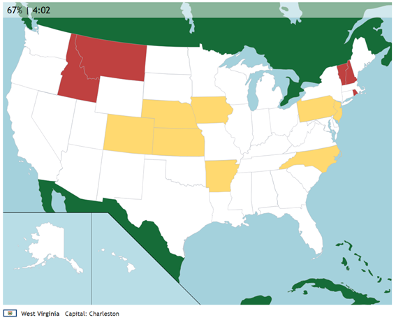
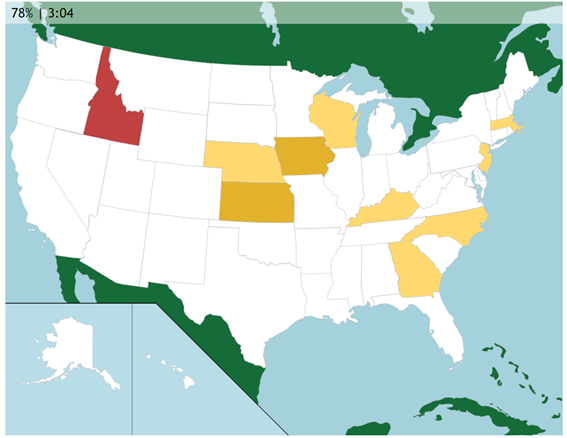
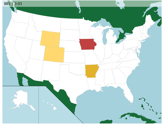
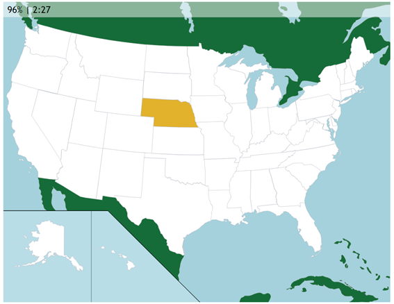 This one got me pretty angry...
-
I think you need to explain this "test"....
and why would you get angry over Nebraska. No one gets mad at Nebraska.
-
I think you need to explain this "test"....
and why would you get angry over Nebraska. No one gets mad at Nebraska.
I think you need to explain this "test"....
and why would you get angry over Nebraska. No one gets mad at Nebraska.
Click the link and check the exercise, man. And you got many unimportant states in that middle area no one knows about... Thank God Kentucky resembles a fried chicken finger.
-
I think you need to explain this "test"....
and why would you get angry over Nebraska. No one gets mad at Nebraska.
Click the link and check the exercise, man. And you got many unimportant states in that middle area no one knows about... Thank God Kentucky resembles a fried chicken finger.
Click the link and check the exercise, man. And you got many unimportant states in that middle area no one knows about... Thank God Kentucky resembles a fried chicken finger.
You could end up with a pitchfork right up your ass by a farmer for that comment. Those "unimportant" states is the area that primarily feeds this planet.
. The United States
No country produces food as efficiently as the U.S. Despite having a significantly smaller workforce than China, total U.S. agricultural product is almost as high. Food production is spread across much of the country, but the largest food-producing states include California, Iowa, Texas, Nebraska and Illinois.
American companies dominate the food export market. Second-place Netherlands exports 35% less than the U.S. and is closer to tenth-place China in terms of international product. The U.S. has been the world's largest exporter of food for a very long time thanks to an increasingly productive farming sector. In fact, the total food production in the U.S. has more than doubled in the post-war period.
Twelve (12) states generate over $10 billion in agricultural cash reciepts: California, Iowa, Nebraska, Texas, Minnesota, Illinois, Kansas, Wisconsin, Indiana, North Carolina, Ohio & South Dakota.
-
Click the link and check the exercise, man. And you got many unimportant states in that middle area no one knows about... Thank God Kentucky resembles a fried chicken finger.
You could end up with a pitchfork right up your ass by a farmer for that comment. Those "unimportant" states is the area that primarily feeds this planet.
. The United States
No country produces food as efficiently as the U.S. Despite having a significantly smaller workforce than China, total U.S. agricultural product is almost as high. Food production is spread across much of the country, but the largest food-producing states include California, Iowa, Texas, Nebraska and Illinois.
American companies dominate the food export market. Second-place Netherlands exports 35% less than the U.S. and is closer to tenth-place China in terms of international product. The U.S. has been the world's largest exporter of food for a very long time thanks to an increasingly productive farming sector. In fact, the total food production in the U.S. has more than doubled in the post-war period.
Twelve (12) states generate over $10 billion in agricultural cash reciepts: California, Iowa, Nebraska, Texas, Minnesota, Illinois, Kansas, Wisconsin, Indiana, North Carolina, Ohio & South Dakota.
You could end up with a pitchfork right up your ass by a farmer for that comment. Those "unimportant" states is the area that primarily feeds this planet.
. The United States
No country produces food as efficiently as the U.S. Despite having a significantly smaller workforce than China, total U.S. agricultural product is almost as high. Food production is spread across much of the country, but the largest food-producing states include California, Iowa, Texas, Nebraska and Illinois.
American companies dominate the food export market. Second-place Netherlands exports 35% less than the U.S. and is closer to tenth-place China in terms of international product. The U.S. has been the world's largest exporter of food for a very long time thanks to an increasingly productive farming sector. In fact, the total food production in the U.S. has more than doubled in the post-war period.
Twelve (12) states generate over $10 billion in agricultural cash reciepts: California, Iowa, Nebraska, Texas, Minnesota, Illinois, Kansas, Wisconsin, Indiana, North Carolina, Ohio & South Dakota.
I bet that farmer would look for me going south of Texas...
Interesting data, though!
-
I think you need to explain this "test"....
and why would you get angry over Nebraska. No one gets mad at Nebraska.
Click the link and check the exercise, man. And you got many unimportant states in that middle area no one knows about... Thank God Kentucky resembles a fried chicken finger.
Click the link and check the exercise, man. And you got many unimportant states in that middle area no one knows about... Thank God Kentucky resembles a fried chicken finger.
Couldn't tell, but the test was to name the state associated with the number? Very tough for a European. I would kill that one, I'm pretty good at geography.
 If you notice my interests, one is mountaineering. There's a Highpointers Club, get to the highest point of every state, many folks have done it, and Denali in Alaska is a real challenge by any standard. My count stands at six, though you can ride a bicycle to the high points of Ohio (Campbell Hill) and Indiana (Hoosier Hill- that doesn't even look like a hill). Most definitely can't ride a bike up Gannett Peak in Wyoming.
Gipper was being modest- he's been to all 50 states, some of them multiple times.
-
Click the link and check the exercise, man. And you got many unimportant states in that middle area no one knows about... Thank God Kentucky resembles a fried chicken finger.
Couldn't tell, but the test was to name the state associated with the number? Very tough for a European. I would kill that one, I'm pretty good at geography.
If you notice my interests, one is mountaineering. There's a Highpointers Club, get to the highest point of every state, many folks have done it, and Denali in Alaska is a real challenge by any standard. My count stands at six, though you can ride a bicycle to the high points of Ohio (Campbell Hill) and Indiana (Hoosier Hill- that doesn't even look like a hill). Most definitely can't ride a bike up Gannett Peak in Wyoming.
Gipper was being modest- he's been to all 50 states, some of them multiple times.
Couldn't tell, but the test was to name the state associated with the number? Very tough for a European. I would kill that one, I'm pretty good at geography.
If you notice my interests, one is mountaineering. There's a Highpointers Club, get to the highest point of every state, many folks have done it, and Denali in Alaska is a real challenge by any standard. My count stands at six, though you can ride a bicycle to the high points of Ohio (Campbell Hill) and Indiana (Hoosier Hill- that doesn't even look like a hill). Most definitely can't ride a bike up Gannett Peak in Wyoming.
Gipper was being modest- he's been to all 50 states, some of them multiple times.
I have been to ALL of them multiple times actually.....except Alaska. Just one time there....Unless you count the fact that during the same trip I went from Alaska over to The Yukon, and then came back to Alaska...as two trips? I do not.

FYI....on a recent trip, I hit the high points to both Illinois and Iowa. I have not really made it a point to hit all the high points...in terms of climbing to them. I have seen quite a few....but not physically gone to the top:
-
Click the link and check the exercise, man. And you got many unimportant states in that middle area no one knows about... Thank God Kentucky resembles a fried chicken finger.
Couldn't tell, but the test was to name the state associated with the number? Very tough for a European. I would kill that one, I'm pretty good at geography.
If you notice my interests, one is mountaineering. There's a Highpointers Club, get to the highest point of every state, many folks have done it, and Denali in Alaska is a real challenge by any standard. My count stands at six, though you can ride a bicycle to the high points of Ohio (Campbell Hill) and Indiana (Hoosier Hill- that doesn't even look like a hill). Most definitely can't ride a bike up Gannett Peak in Wyoming.
Gipper was being modest- he's been to all 50 states, some of them multiple times.
Couldn't tell, but the test was to name the state associated with the number?
With the number of the state? Only US citizens care to learn that. The program asks you for a state then you click on it.
Very tough for a European. I would kill that one, I'm pretty good at geography.
I'm pretty good a geography too. Fun fact, I'd say that it is easier to learn the countries in Europe because they have a lot of History behind them. French-Spanish wars, Portugal allied with Spain, French always having trouble with the Channel, the isolationist Britain, Rome (the now Italy) being a Mediterranean power, Austorhungarian Empire on WWI, Germany invading Poland...
You can mess up with some smaller countries closer to Russia (the steel curtain was not only a metaphor) or the Balkans due to recent wars, but you can make your way around...
-
Elevations of the 50 states, the federal district, and the territories[1][7][8]
I am highlighting in red the ones I have physically been to. Others in like Orange I have seen visually but not been to the top
State
federal district
or territory Highest point Highest elevation Rank (High point) Lowest point Lowest elevation Mean elevation Elevation span Alabama Cheaha Mountain[9] 2,413 ft
736 m 38 Gulf of Mexico sea level 500 ft
150 m 2,413 ft
736 m Alaska Denali[10] 20,310 ft
6190.5 m 1 Gulf of Alaska, Bering Sea, and Arctic Ocean sea level 1,900 ft
580 m 20,310 ft
6190.5 m American Samoa Lata Mountain on Ta‘ū island[11] 3,163 ft
964 m 36 Pacific Ocean sea level NA 3,163 ft
964 m Arizona Humphreys Peak[12] 12,637 ft
3852 m 12 Colorado River at Sonora border, San Luis, Arizona 72 ft
22 m 4,100 ft
1250 m 12,565 ft
3830 m Arkansas Mount Magazine[13] 2,753 ft
839 m 37 Ouachita River at Louisiana border 55 ft
17 m 650 ft
200 m 2,698 ft
822 m California Mount Whitney[14][15] 14,505 ft
4421.0 m 2 Badwater Basin in Death Valley[1][2][16]−279 ft
−85 m 2,900 ft
880 m 14,783 ft
4506 m Colorado Mount Elbert[17][18] 14,440 ft
4401.2 m 3 Arikaree River at Kansas border[19][20] 3,317 ft
1011 m 6,800 ft
2070 m 11,123 ft
3390 m Connecticut Massachusetts border on south side of Mount Frissell[21] 2,379 ft
725 m 39 Long Island Sound sea level 500 ft
150 m 2,379 ft
725 m Delaware Near the Ebright Azimuth[22][23] 447 ft
136 m 54 Atlantic Ocean sea level 60 ft
20 m 447 ft
136 m District of Columbia Fort Reno[24] 409 ft
125 m 55 Potomac River at eastern Maryland border 1.0 ft
0.3 m 150 ft
50 m 408 ft
124 m Florida Britton Hill 345 ft
105 m 56 Atlantic Ocean and Gulf of Mexico sea level 100 ft
30 m 345 ft
105 m Georgia Brasstown Bald 4,784 ft
1458 m 25 Atlantic Ocean sea level 600 ft
180 m 4,784 ft
1458 m Guam Mount Lamlam 1,332 ft
406 m[25] 48 Pacific Ocean sea level NA 1,332 ft
406 m Hawaii Mauna Kea[26][27] on the Island of Hawai'i 13,803 ft
4207 m 6 Pacific Ocean sea level 3,030 ft
920 m 13,803 ft
4207 m Idaho Borah Peak[28] 12,668 ft
3861 m 11 Confluence of Snake River and Clearwater River 713 ft
217 m 5,000 ft
1520 m 11,954 ft
3644 m Illinois Charles Mound[29] 1,235 ft
376 m 50 Confluence of Mississippi River and Ohio River 280 ft
85 m 600 ft
180 m 955 ft
291 m Indiana Hoosier Hill 1,257 ft
383 m 49 Confluence of Wabash River and Ohio River 320 ft
97 m 700 ft
210 m 937 ft
286 m Iowa Hawkeye Point 1,671 ft
509 m 45 Confluence of Mississippi River and Des Moines River 480 ft
146 m 1,100 ft
340 m 1,191 ft
363 m Kansas Mount Sunflower 4,041 ft
1232 m 29 Verdigris River at Oklahoma border 679 ft
207 m 2,000 ft
610 m 3,361 ft
1025 m Kentucky Black Mountain 4,145 ft
1263 m 28 Mississippi River at Kentucky Bend 257 ft
78 m 750 ft
230 m 3,887 ft
1185 m Louisiana Driskill Mountain 535 ft
163 m 53 New Orleans −8 ft
−2.4 m 100 ft
30 m 543 ft
165 m Maine Mount Katahdin[30] 5,270 ft
1606.4 m 22 Atlantic Ocean sea level 600 ft
180 m 5,270 ft
1606.4 m Maryland Hoye-Crest 3,360 ft
1024 m 33 Atlantic Ocean sea level 350 ft
110 m 3,360 ft
1024 m Massachusetts Mount Greylock[31] 3,489 ft
1063 m 32 Atlantic Ocean sea level 500 ft
150 m 3,489 ft
1063 m Michigan Mount Arvon 1,979 ft
603 m 41 Lake Erie 571 ft
174 m 900 ft
270 m 1,408 ft
429 m Minnesota Eagle Mountain 2,302 ft
701 m 40 Lake Superior 601 ft
183 m 1,200 ft
370 m 1,700 ft
518 m Mississippi Woodall Mountain[32] 807 ft
246 m 52 Gulf of Mexico sea level 300 ft
90 m 807 ft
246 m Missouri Taum Sauk Mountain 1,772 ft
540 m 44 Saint Francis River at southern Arkansas border 230 ft
70 m 800 ft
240 m 1,542 ft
470 m Montana Granite Peak[33] 12,807 ft
3903.5 m 10 Kootenai River at Idaho border 1,804 ft
550 m 3,400 ft
1040 m 11,003 ft
3354 m Nebraska Panorama Point 5,427 ft
1654 m 20 Missouri River at Kansas border 840 ft
256 m 2,600 ft
790 m 4,587 ft
1398 m Nevada Boundary Peak[34] 13,147 ft
4007 m 9 Colorado River at California border 481 ft
147 m 5,500 ft
1680 m 12,665 ft
3860 m New Hampshire Mount Washington[35][36] 6,288 ft
1917 m 18 Atlantic Ocean sea level 1,000 ft
300 m 6,288 ft
1917 m New Jersey High Point 1,803 ft
550 m 43 Atlantic Ocean sea level 250 ft
80 m 1,803 ft
550 m New Mexico Wheeler Peak[37] 13,167 ft
4013.3 m 8 Red Bluff Reservoir on Texas border 2,844 ft
867 m 5,700 ft
1740 m 10,323 ft
3147 m New York Mount Marcy[38] 5,343 ft
1628.57 m 21 Atlantic Ocean sea level 1,000 ft
300 m 5,343 ft
1628.57 m North Carolina Mount Mitchell[39] 6,684 ft
2037 m 16 Atlantic Ocean sea level 700 ft
210 m 6,684 ft
2037 m North Dakota White Butte 3,508 ft
1069 m 31 Red River of the North at Manitoba border 751 ft
229 m 1,900 ft
580 m 2,757 ft
840 m Northern Mariana Islands Unnamed point on Agrihan island 3,166 ft
965 m[40] 35 Pacific Ocean sea level NA 3,166 ft
965 m Ohio Campbell Hill 1,549 ft
472 m 47 Ohio River at Indiana border 455 ft
139 m 850 ft
260 m 1,094 ft
333 m Oklahoma Black Mesa 4,975 ft
1516 m 23 Little River at Arkansas border 289 ft
88 m 1,300 ft
400 m 4,686 ft
1428 m Oregon Mount Hood[41] 11,249 ft
3428.8 m 13 Pacific Ocean sea level 3,300 ft
1010 m 11,249 ft
3428.8 m Pennsylvania Mount Davis 3,213 ft
979 m 34 Delaware River at Delaware border sea level 1,100 ft
340 m 3,213 ft
979 m Puerto Rico Cerro de Punta 4,390 ft
1338 m[42] 27 Atlantic Ocean (Caribbean sea) sea level 856 ft
261 m 4,390 ft
1338 m Rhode Island Jerimoth Hill 811 ft
247 m 51 Atlantic Ocean sea level 200 ft
60 m 811 ft
247 m South Carolina Sassafras Mountain 3,560 ft
1085 m 30 Atlantic Ocean sea level 350 ft
110 m 3,560 ft
1085 m South Dakota Black Elk Peak[43] 7,244 ft
2208 m 15 Big Stone Lake on Minnesota border 968 ft
295 m 2,200 ft
670 m 6,276 ft
1913 m Tennessee Clingmans Dome 6,643 ft
2025 m 17 Mississippi River at Mississippi border 178 ft
54 m 900 ft
270 m 6,466 ft
1971 m Texas Guadalupe Peak[44] 8,751 ft
2667 m 14 Gulf of Mexico sea level 1,700 ft
520 m 8,751 ft
2667 m United States Minor Outlying Islands Unnamed point on Navassa Island 279 ft
85 m[45] 57 Pacific Ocean (8 islands) and Caribbean Sea(Navassa Island) sea level NA 279 ft
85 m Utah Kings Peak[46] 13,534 ft
4125 m 7 Beaver Dam Wash at Arizona border 2,180 ft
664 m 6,100 ft
1860 m 11,354 ft
3461 m Vermont Mount Mansfield[47] 4,395 ft
1340 m 26 Lake Champlain 95 ft
29 m 1,000 ft
300 m 4,300 ft
1311 m Virgin Islands (U.S.) Crown Mountain on the island of Saint Thomas 1,555 ft
474 m[48] 46 Atlantic Ocean (Caribbean Sea) sea level NA 1,555 ft
474 m Virginia Mount Rogers 5,729 ft
1746 m 19 Atlantic Ocean sea level 950 ft
290 m 5,729 ft
1746 m Washington Mount Rainier[49] 14,417 ft
4394 m 4 Pacific Ocean sea level 1,700 ft
520 m 14,417 ft
4394 m West Virginia Spruce Knob[50] 4,863 ft
1482.1 m 24 Potomac River at Virginia border 240 ft
73 m 1,500 ft
460 m 4,623 ft
1409 m Wisconsin Timms Hill 1,951 ft
595 m 42 Lake Michigan 579 ft
176 m 1,050 ft
320 m 1,372 ft
418 m Wyoming Gannett Peak[51] 13,809 ft
4209.1 m 5 Belle Fourche River at South Dakota border 3,101 ft
945 m 6,700 ft
2040 m 10,709 ft
3264 m United States Denali,[10] Alaska 20,310 ft
6190.5 m Badwater Basin,[16] California -
Couldn't tell, but the test was to name the state associated with the number?
With the number of the state? Only US citizens care to learn that. The program asks you for a state then you click on it.
Very tough for a European. I would kill that one, I'm pretty good at geography.
I'm pretty good a geography too. Fun fact, I'd say that it is easier to learn the countries in Europe because they have a lot of History behind them. French-Spanish wars, Portugal allied with Spain, French always having trouble with the Channel, the isolationist Britain, Rome (the now Italy) being a Mediterranean power, Austorhungarian Empire on WWI, Germany invading Poland...
You can mess up with some smaller countries closer to Russia (the steel curtain was not only a metaphor) or the Balkans due to recent wars, but you can make your way around...
With the number of the state? Only US citizens care to learn that. The program asks you for a state then you click on it.
I'm pretty good a geography too. Fun fact, I'd say that it is easier to learn the countries in Europe because they have a lot of History behind them. French-Spanish wars, Portugal allied with Spain, French always having trouble with the Channel, the isolationist Britain, Rome (the now Italy) being a Mediterranean power, Austorhungarian Empire on WWI, Germany invading Poland...
You can mess up with some smaller countries closer to Russia (the steel curtain was not only a metaphor) or the Balkans due to recent wars, but you can make your way around...
Well.....a bit of a problem with some parts of Europe is that they can't keep straight what areas are supposed to be a country and what is not? Particularly the Balkans. Moldova, Macedonia, Montenegro, Bosnia, Herzegovinia etc. etc.
What was wrong with just having Yugoslavia?
And from what I understand....part of Spain is actually in Africa? And Turkey is part Europe, part Asia? I mean for fuck's sake at least figure out what continent you're on.🥷
-
Not going to quote Gipper's entire list of state high points, but it did get me a little worried. South Dakota, Black Elk Peak? I climbed it when it was called Harney Peak, they changed the name.
Some Ohioans got bent out of shape when the US Geological Survey (rightfully) changed the name of Mount McKinley (former US president from Ohio) to the local native name Denali- "the high one".
Now if the Nepalese government would grow a set and change the name of Mount Everest (some damn British surveyor) back to what it belongs, Chomolungma or Sagamartha, it would make me happy. Very few of the other major Himalayan peaks got this treatment. K2 is so remote, even the locals didn't have a name for it.
PS, my Himalayan cat Norman's middle name after a peak is Namcha Barwa. Didn't like the sound of Nanga Parbat, and Nanda Devi is named after a woman Hindu goddess, Norman is a boy. Nuptse might have worked. See why "Mount Everest" is SO out of place?
-
Not going to quote Gipper's entire list of state high points, but it did get me a little worried. South Dakota, Black Elk Peak? I climbed it when it was called Harney Peak, they changed the name.
Some Ohioans got bent out of shape when the US Geological Survey (rightfully) changed the name of Mount McKinley (former US president from Ohio) to the local native name Denali- "the high one".
Now if the Nepalese government would grow a set and change the name of Mount Everest (some damn British surveyor) back to what it belongs, Chomolungma or Sagamartha, it would make me happy. Very few of the other major Himalayan peaks got this treatment. K2 is so remote, even the locals didn't have a name for it.
PS, my Himalayan cat Norman's middle name after a peak is Namcha Barwa. Didn't like the sound of Nanga Parbat, and Nanda Devi is named after a woman Hindu goddess, Norman is a boy. Nuptse might have worked. See why "Mount Everest" is SO out of place?
Not going to quote Gipper's entire list of state high points, but it did get me a little worried. South Dakota, Black Elk Peak? I climbed it when it was called Harney Peak, they changed the name.
Some Ohioans got bent out of shape when the US Geological Survey (rightfully) changed the name of Mount McKinley (former US president from Ohio) to the local native name Denali- "the high one".
Now if the Nepalese government would grow a set and change the name of Mount Everest (some damn British surveyor) back to what it belongs, Chomolungma or Sagamartha, it would make me happy. Very few of the other major Himalayan peaks got this treatment. K2 is so remote, even the locals didn't have a name for it.
PS, my Himalayan cat Norman's middle name after a peak is Namcha Barwa. Didn't like the sound of Nanga Parbat, and Nanda Devi is named after a woman Hindu goddess, Norman is a boy. Nuptse might have worked. See why "Mount Everest" is SO out of place?
Yea, I wondered about it. The name had always been Harney Peak.....I thought maybe after a new survey that they had found a higher point somewhere....instead of just a name change.
But, wasn't Everest basically the guy that was responsible for determining that that peak was the highest point on earth? So, it does not bother me.
There are thousands and thousands of geological features on earth where a native population probably had their own name for them. Mountains, lakes, rivers, swamps etc. Half the states themselves have native American names....including Ohio....which means basically: "Its beautiful".
The river a few blocks from where I sit: The Tuscarawas means "Open Mouth"
Here are Indian names of counties in Ohio:
https://www.dispatch.com/article/20081119/lifestyle/311199650
-
Couldn't tell, but the test was to name the state associated with the number?
With the number of the state? Only US citizens care to learn that. The program asks you for a state then you click on it.
Very tough for a European. I would kill that one, I'm pretty good at geography.
I'm pretty good a geography too. Fun fact, I'd say that it is easier to learn the countries in Europe because they have a lot of History behind them. French-Spanish wars, Portugal allied with Spain, French always having trouble with the Channel, the isolationist Britain, Rome (the now Italy) being a Mediterranean power, Austorhungarian Empire on WWI, Germany invading Poland...
You can mess up with some smaller countries closer to Russia (the steel curtain was not only a metaphor) or the Balkans due to recent wars, but you can make your way around...
With the number of the state? Only US citizens care to learn that. The program asks you for a state then you click on it.
I'm pretty good a geography too. Fun fact, I'd say that it is easier to learn the countries in Europe because they have a lot of History behind them. French-Spanish wars, Portugal allied with Spain, French always having trouble with the Channel, the isolationist Britain, Rome (the now Italy) being a Mediterranean power, Austorhungarian Empire on WWI, Germany invading Poland...
You can mess up with some smaller countries closer to Russia (the steel curtain was not only a metaphor) or the Balkans due to recent wars, but you can make your way around...
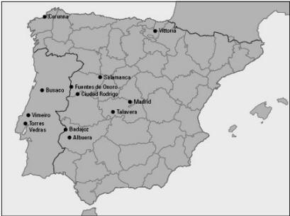
Because it was the subject of a lot of books by my favorite author,...who wrote a lot of historical fiction about it, I have had some interest in the battle sites of the Peninsular War.
-
In re the above post, I am referring to the Sharpe novels by Bernard Cornwell. A few of these novels took place in other settings...India/Waterloo etc....but most were in Spain/Portugal:
https://www.goodreads.com/series/40550-richard-sharpe-chronological-order
-
With the number of the state? Only US citizens care to learn that. The program asks you for a state then you click on it.
I'm pretty good a geography too. Fun fact, I'd say that it is easier to learn the countries in Europe because they have a lot of History behind them. French-Spanish wars, Portugal allied with Spain, French always having trouble with the Channel, the isolationist Britain, Rome (the now Italy) being a Mediterranean power, Austorhungarian Empire on WWI, Germany invading Poland...
You can mess up with some smaller countries closer to Russia (the steel curtain was not only a metaphor) or the Balkans due to recent wars, but you can make your way around...
Because it was the subject of a lot of books by my favorite author,...who wrote a lot of historical fiction about it, I have had some interest in the battle sites of the Peninsular War.
Because it was the subject of a lot of books by my favorite author,...who wrote a lot of historical fiction about it, I have had some interest in the battle sites of the Peninsular War.
LOL Gipper- I like this map of Spain better.
 Rioja was the wine & area that got me to realize there were better wines than Boone's Farm and Annie Green Springs. If you look way down at the bottom right near Murcia way, the wine I really like, and wowed Tex Ag (Clio) is from the Jumilla region... Also, near Gibraltar you have Jerez de La Frontera, the home of "real" sherry.... Some of the areas that are currently on wine aficionados hot list with rapidly rising prices are Toro and Ribera del Duero. OK, I can't help myself, I'm on a roll- when the Duero River crosses into Portugal it name changes to the Duro, and if you see that town on the Atlantic Porto, that's where "real" port comes from, and I don't accept any American or Australian imitations as anywhere close to the real thing.

-
Because it was the subject of a lot of books by my favorite author,...who wrote a lot of historical fiction about it, I have had some interest in the battle sites of the Peninsular War.
LOL Gipper- I like this map of Spain better.
Rioja was the wine & area that got me to realize there were better wines than Boone's Farm and Annie Green Springs. If you look way down at the bottom right near Murcia way, the wine I really like, and wowed Tex Ag (Clio) is from the Jumilla region... Also, near Gibraltar you have Jerez de La Frontera, the home of "real" sherry.... Some of the areas that are currently on wine aficionados hot list with rapidly rising prices are Toro and Ribera del Duero. OK, I can't help myself, I'm on a roll- when the Duero River crosses into Portugal it name changes to the Duro, and if you see that town on the Atlantic Porto, that's where "real" port comes from, and I don't accept any American or Australian imitations as anywhere close to the real thing.
LOL Gipper- I like this map of Spain better.
Rioja was the wine & area that got me to realize there were better wines than Boone's Farm and Annie Green Springs. If you look way down at the bottom right, the wine I really like, and wowed Tex Ag (Clio) is from the Jumilla region... Also, near Gibraltar you have Jerez de La Frontera, the home of "real" sherry.... Some of the areas that are currently on wine aficionados hot list with rapidly rising prices are Toro and Ribera del Duero. OK, I can't help myself, I'm on a roll- when the Duero River crosses into Portugal it name changes to the Duro, and if you see that town on the Atlantic Porto, that's where "real" port comes from, and I don't accept any American or Australian imitations as anywhere close to the real thing.
I'm amazed that a map made in Seattle mentions Hondarribi, my mom's hometown in Basque Country (though it is touching with France and you don't see it highlighted).
-
Because it was the subject of a lot of books by my favorite author,...who wrote a lot of historical fiction about it, I have had some interest in the battle sites of the Peninsular War.
LOL Gipper- I like this map of Spain better.
Rioja was the wine & area that got me to realize there were better wines than Boone's Farm and Annie Green Springs. If you look way down at the bottom right near Murcia way, the wine I really like, and wowed Tex Ag (Clio) is from the Jumilla region... Also, near Gibraltar you have Jerez de La Frontera, the home of "real" sherry.... Some of the areas that are currently on wine aficionados hot list with rapidly rising prices are Toro and Ribera del Duero. OK, I can't help myself, I'm on a roll- when the Duero River crosses into Portugal it name changes to the Duro, and if you see that town on the Atlantic Porto, that's where "real" port comes from, and I don't accept any American or Australian imitations as anywhere close to the real thing.
LOL Gipper- I like this map of Spain better.
Rioja was the wine & area that got me to realize there were better wines than Boone's Farm and Annie Green Springs. If you look way down at the bottom right near Murcia way, the wine I really like, and wowed Tex Ag (Clio) is from the Jumilla region... Also, near Gibraltar you have Jerez de La Frontera, the home of "real" sherry.... Some of the areas that are currently on wine aficionados hot list with rapidly rising prices are Toro and Ribera del Duero. OK, I can't help myself, I'm on a roll- when the Duero River crosses into Portugal it name changes to the Duro, and if you see that town on the Atlantic Porto, that's where "real" port comes from, and I don't accept any American or Australian imitations as anywhere close to the real thing.
Its a better map....but it doesn't show the Battles of the Peninsular War......It just shows where best to get drunk.....which of course, would be important if you were there fighting a war.
-
I'm looking forward to the Super Bowl just like I have for most of my 51 years of life. I'll update this forum with the score, since it seems no one else will be watching.
Carry on with the conspiracy theories, I always like a good fiction novel before bed...... Go Rams, and most importantly:
RUN THE BALL SEAN!!
I'm looking forward to the Super Bowl just like I have for most of my 51 years of life. I'll update this forum with the score, since it seems no one else will be watching.
Carry on with the conspiracy theories, I always like a good fiction novel before bed...... Go Rams, and most importantly:
RUN THE BALL SEAN!!
That was GREAT! I got 2 minutes abs after I hit the deck laughing at your clinic on how to be the biggest BASTARD in 1 easy post.
-
I'm looking forward to the Super Bowl just like I have for most of my 51 years of life. I'll update this forum with the score, since it seems no one else will be watching.
Carry on with the conspiracy theories, I always like a good fiction novel before bed...... Go Rams, and most importantly:
RUN THE BALL SEAN!!
That was GREAT! I got 2 minutes abs after I hit the deck laughing at your clinic on how to be the biggest BASTARD in 1 easy post.






Hello! It looks like you're interested in this conversation, but you don't have an account yet.
Getting fed up of having to scroll through the same posts each visit? When you register for an account, you'll always come back to exactly where you were before, and choose to be notified of new replies (either via email, or push notification). You'll also be able to save bookmarks and upvote posts to show your appreciation to other community members.
With your input, this post could be even better 💗
Register Login