
Survey is Back
-

-

-

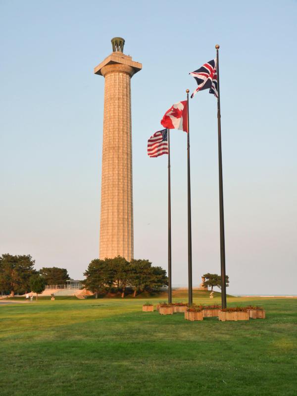
Back when the Terminal tower was the only one in town
-
-

-
Sears (now called Willis) Tower, Gateway Arch, Terminal Tower.
And I got you way beat in the mountain altitude game Gip. there is a thing called the Highpointers Club. You may have been to all 50 states- now get to the top of every one.
 My score: Ohio, Indiana, Tennessee, South Dakota, Wyoming, Colorado.
I do like the concept of the highpointers club.. I have perhaps been to a few....but only the very low ones. Just a few years ago I know I was at the "Highpoint State Park" in New Jersey. At the highpoint of the state they enhanced it by building a 200 foot tower to walk up.
In Florida, the high point is just the top of a grade at the side of a road.
I've been to Clingman's Dome, top of Mount Washington
I have "gazed upon" a few others from a distance, but never climbed to the top.
http://www.peakbagger.com/list.aspx?lid=12004
Sears (now called Willis) Tower, Gateway Arch, Terminal Tower.
And I got you way beat in the mountain altitude game Gip. there is a thing called the Highpointers Club. You may have been to all 50 states- now get to the top of every one.
My score: Ohio, Indiana, Tennessee, South Dakota, Wyoming, Colorado. I do like the concept of the highpointers club.. I have perhaps been to a few....but only the very low ones. Just a few years ago I know I was at the "Highpoint State Park" in New Jersey. At the highpoint of the state they enhanced it by building a 200 foot tower to walk up.
In Florida, the high point is just the top of a grade at the side of a road.
I've been to Clingman's Dome, top of Mount Washington
I have "gazed upon" a few others from a distance, but never climbed to the top.
Yeah Gipper- you can drive right up to the Ebright Azimuth in Delaware, and Mount Elbert is prominently visible from near anywhere in Leadville Colorado. Speaking of Mount Elbert- it's the only time I've ever seen a porcupine in the wild- running around my campsite.

Campbell Hill- which is just outside of Bellfontaine Ohio, you can easily ride a bike to the top. At least it resembles a hill

Unlike Hoosier Hill, which isn't really much of a hill. (Just on the other side of the Ohio state line.) I rode my bike over there, and I could have sworn there was a spot on the road that looked a couple of feet higher- it's part of a guy's farm. You can almost drive a car to the top of Clingman's Dome, and from there it's just a short walk.
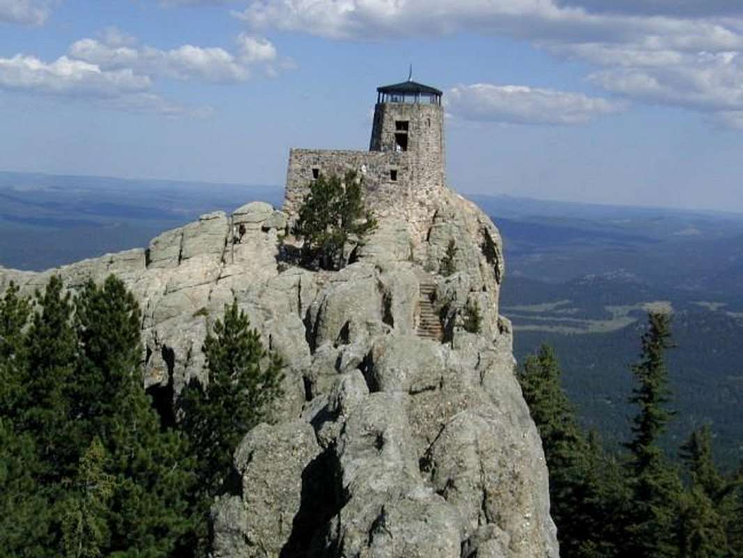
The others are slightly more challenging. The amazing thing about Harney Peak in the Black Hills is during the depression- they had a work crew build this three story rock fire lookout on top of a 7,000' mountain.
Gannet Peak in Wyoming is usually considered #2 in degree of difficulty after Denali in Alaska. (Though I might disagree after perusing the climbing route on Granite Peak in Montana.) A lot of people mistakenly think the Grand Teton is Wyoming's highpoint- but it's not. The Grand- been there, done that- is way more technically difficult, you had better know how to use a rope, and how to rappel. The first roped pitch, you're on an exposed boulder slab with 2,000' of air underneath you. The pine trees look like dots. Regarding Gannett- lotsa fun hiking 25 miles to Titcomb Basin with a 70 pound mountaineering pack, then going 1,000' up (and down) over Bonney Pass, and you still have to climb the booger. FWIW, I have a near identical framed picture in my bedroom I took from the the exact same spot at the top of Bonney Pass.

PS Gip, regarding your picture of the Twin Towers. When Bin Laden took them down- he also ruined a couple million bucks worth of high end wine that was stashed at Windows on the World restaurant that was at the top of one of them.

-
I have been at that point in Ohio you have a picture of. I mean, there is a house and some kind of a tank. It doesn't look like you can actually get to the apex there.
And Florida has just a sign there:
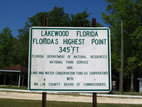
There may be a marker on the ground somewhere behind this sign.
-
I have driven the road up Mt. Whitney as far as it would take me, but it does not go all the way to the top. I did not climb the rest of the way there.

-
I have been at that point in Ohio you have a picture of. I mean, there is a house and some kind of a tank. It doesn't look like you can actually get to the apex there.
And Florida has just a sign there:
There may be a marker on the ground somewhere behind this sign.
I have been at that point in Ohio you have a picture of. I mean, there is a house and some kind of a tank. It doesn't look like you can actually get to the apex there.
LOL Gip- you're right. You'd have to have them let you climb the ladder to the top of the water tower to be at the "true" highpoint- but in this case, I don't think man made structures count. There's a career center there- as well as the remnants of a WW II radar station.
From the top- it really doesn't look like you're that high up- until you get on your bike, and motor down Ohio 540 into Bellefontaine at 30 mph.
-
I have driven the road up Mt. Whitney as far as it would take me, but it does not go all the way to the top. I did not climb the rest of the way there.
I have driven the road up Mt. Whitney as far as it would take me, but it does not go all the way to the top. I did not climb the rest of the way there.
Didn't realize there's a road going most of the way up. I have this debate if you drive to the top, you really haven't "climbed" it, like Pike's Peak.
Regarding Whitney- you're not taking a car up the West side. Rock jock territory.
-
I have been at that point in Ohio you have a picture of. I mean, there is a house and some kind of a tank. It doesn't look like you can actually get to the apex there.
LOL Gip- you're right. You'd have to have them let you climb the ladder to the top of the water tower to be at the "true" highpoint- but in this case, I don't think man made structures count. There's a career center there- as well as the remnants of a WW II radar station.
From the top- it really doesn't look like you're that high up- until you get on your bike, and motor down Ohio 540 into Bellefontaine at 30 mph.
LOL Gip- you're right. You'd have to have them let you climb the ladder to the top of the water tower to be at the "true" highpoint- but in this case, I don't think man made structures count. There's a career center there- as well as the remnants of a WW II radar station.
From the top- it really doesn't look like you're that high up- until you get on your bike, and motor down Ohio 540 into Bellefontaine at 30 mph.
I went to the top of the south rim of the Grand Canyon this summer. Had to be at least 200 ft. over from the parking lot.


-
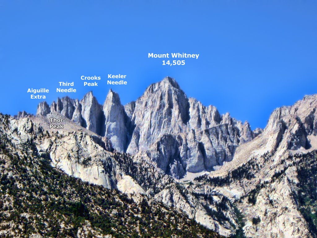
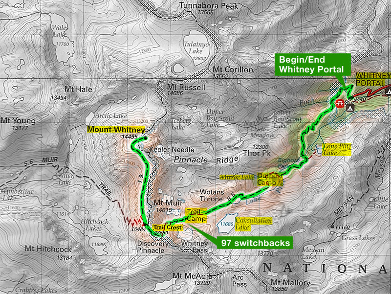
The Portal road to Mt. Whitney only goes about halfway up. According to this map it stops at the 8340 foot mark....and Whitney is 14495. So there is still a long way to walk up. Over a mile straight.
-
The Portal road to Mt. Whitney only goes about halfway up. According to this map it stops at the 8340 foot mark....and Whitney is 14495. So there is still a long way to walk up. Over a mile straight.
The Portal road to Mt. Whitney only goes about halfway up. According to this map it stops at the 8340 foot mark....and Whitney is 14495. So there is still a long way to walk up. Over a mile straight.
Thanks for the map Gip. I looked it up, and from the end of the road, if you're doing it in one day, it's a round trip of 22 miles, with 6,000' of elevation gain- a lot of it at over 10,000' elevation. By my standards- that's an ass-kicking hike. (The equivalent for us flat landers, @ 14,000' walking up two flights of stairs, and you'd have to rest for a few seconds.) I've only done more than 20 miles in a day once, way back in the 70s when I took a wrong trail junction in the Bridger Wilderness and had to backtrack. I was so beat- I just tossed my sleeping bag next to the car and crashed out.
-
The Portal road to Mt. Whitney only goes about halfway up. According to this map it stops at the 8340 foot mark....and Whitney is 14495. So there is still a long way to walk up. Over a mile straight.
Thanks for the map Gip. I looked it up, and from the end of the road, if you're doing it in one day, it's a round trip of 22 miles, with 6,000' of elevation gain- a lot of it at over 10,000' elevation. By my standards- that's an ass-kicking hike. (The equivalent for us flat landers, @ 14,000' walking up two flights of stairs, and you'd have to rest for a few seconds.) I've only done more than 20 miles in a day once, way back in the 70s when I took a wrong trail junction in the Bridger Wilderness and had to backtrack. I was so beat- I just tossed my sleeping bag next to the car and crashed out.
Thanks for the map Gip. I looked it up, and from the end of the road, if you're doing it in one day, it's a round trip of 22 miles, with 6,000' of elevation gain- a lot of it at over 10,000' elevation. By my standards- that's an ass-kicking hike. (The equivalent for us flat landers, @ 14,000' walking up two flights of stairs, and you'd have to rest for a few seconds.) I've only done more than 20 miles in a day once, way back in the 70s when I took a wrong trail junction in the Bridger Wilderness and had to backtrack. I was so beat- I just tossed my sleeping bag next to the car and crashed out.
Now that you are in your 60s would you want to tackle it? Not I.
-
Oh you two get your old asses up that there hill.
-
Thanks for the map Gip. I looked it up, and from the end of the road, if you're doing it in one day, it's a round trip of 22 miles, with 6,000' of elevation gain- a lot of it at over 10,000' elevation. By my standards- that's an ass-kicking hike. (The equivalent for us flat landers, @ 14,000' walking up two flights of stairs, and you'd have to rest for a few seconds.) I've only done more than 20 miles in a day once, way back in the 70s when I took a wrong trail junction in the Bridger Wilderness and had to backtrack. I was so beat- I just tossed my sleeping bag next to the car and crashed out.
Now that you are in your 60s would you want to tackle it? Not I.
Now that you are in your 60s would you want to tackle it? Not I.
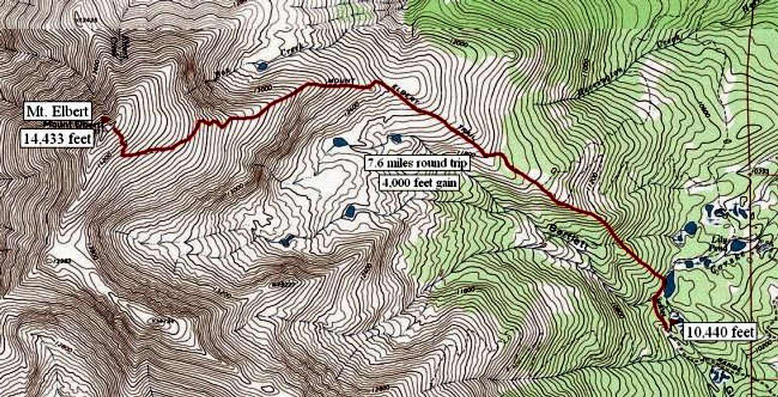
Um- probably not, unless I lost a lot of weight. Climbing Middle Teton with my nephew (Sherpa Joe) four years ago might well have been my last hurrah. 12,000' @ 60 feels like 14,000' @ 28. As you might have read, I did climb Mount Elbert back in 1978. (Whitney is only 62' higher) The difference being- you can drive up almost to the base of the mountain, and it's only 7 miles and change round trip with 4,000' of elevation gain. Even at that altitude, your mind starts playing tricks on you. Thought I ran out of film, so I dumped the contents of my daypack on the ground, looking for the spare roll of film I knew I had packed. Couldn't find it. When I got back to the car, sure enough, it was there- I was staring right at it, and didn't see it.
LOL, a world traveler friend of mine- who's in his 70s recently asked my opinion if I wanted to go take on Kilimanjaro with him. (He has almost no climbing experience.) Told him- you had better try a Colorado 14er on for size, before you take on that Mother. The thought did occur to me standing on top of Elbert- Kilimanjaro or Denali are "only" around another mile of thinner air higher up. Even at Elbert's level- you can clearly see there's a lot of atmosphere beneath you. Since you're a trivia buff Gip- didya know standing @ 18,500' half the earth's air is underneath your feet?
-
One Post From the Truth said:
Oh you two get your old asses up that there hill.
LOL, in my 50s I had delusions of grandeur. Pico de Orizaba in sunny Mexico 18,500'. Or Aconcagua, 22,000' (highest point in the Western Hemisphere) just outside of Santiago, Chile. Probably not now though.
Here's the current age record for Everest: Yuichiro Miura (Japan) reached the summit on 23 May 2013 at the age of 80 years 223 days. (That old fart is in incredible shape)
But researching- for me to have a legit shot at the world's highpoint, based on my climbing Middle Teton, I would have had to make that trip in 1\2 the time carrying a 60 pound pack. Not happening. Not only that- it takes a pile of loot, probably at least $50,000 on a budget tour- to take a trip up the Yellow Brick Road. Last time I looked, the Nepalese government was charging $10k + for the opportunity to get yourself killed.
-
One Post From the Truth said:
Oh you two get your old asses up that there hill.
LOL, in my 50s I had delusions of grandeur. Pico de Orizaba in sunny Mexico 18,500'. Or Aconcagua, 22,000' (highest point in the Western Hemisphere) just outside of Santiago, Chile. Probably not now though.
Here's the current age record for Everest: Yuichiro Miura (Japan) reached the summit on 23 May 2013 at the age of 80 years 223 days. (That old fart is in incredible shape)
But researching- for me to have a legit shot at the world's highpoint, based on my climbing Middle Teton, I would have had to make that trip in 1\2 the time carrying a 60 pound pack. Not happening. Not only that- it takes a pile of loot, probably at least $50,000 on a budget tour- to take a trip up the Yellow Brick Road. Last time I looked, the Nepalese government was charging $10k + for the opportunity to get yourself killed.
I'm sure if you had to it would be a different outlook. I'm chickenshit of bears.LOL, in my 50s I had delusions of grandeur. Pico de Orizaba in sunny Mexico 18,500'. Or Aconcagua, 22,000' (highest point in the Western Hemisphere) just outside of Santiago, Chile. Probably not now though.
Here's the current age record for Everest: Yuichiro Miura (Japan) reached the summit on 23 May 2013 at the age of 80 years 223 days. (That old fart is in incredible shape)
But researching- for me to have a legit shot at the world's highpoint, based on my climbing Middle Teton, I would have had to make that trip in 1\2 the time carrying a 60 pound pack. Not happening.
-
Glad OKC took care of Mexico's team. Now go Cavs.
Still pissed the Stars didn't even show up in game 7 last night.



Hello! It looks like you're interested in this conversation, but you don't have an account yet.
Getting fed up of having to scroll through the same posts each visit? When you register for an account, you'll always come back to exactly where you were before, and choose to be notified of new replies (either via email, or push notification). You'll also be able to save bookmarks and upvote posts to show your appreciation to other community members.
With your input, this post could be even better 💗
Register Login